Search Term Record
Metadata
Search Term |
Ivanhoe Ridge |
Number of Object records |
0 |
Number of Archive records |
5 |
Related Records
-
-
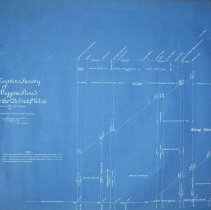
A2021.000.001.002 - Survey, Land
Location profile of the proposed wagon road from Rossland to the Velvet Mine.
Record Type: Archive
-
-
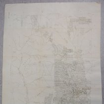
A2021.000.001.057 - Map
Mining claim map of the Trail Creek Mining Division published by the Department of Mines and Petroleum Resources.
Record Type: Archive