Archive Record
Images
Metadata
Catalog Number |
A2021.000.001.017 |
Object Name |
Map |
Tagline |
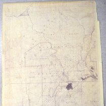
Map of the Rossland area of the West Kootenays. |
Collection |
MS 84 - Map & Plan Collection |
Scope & Content |
Extra-large map of the Rossland area of the West Kootenays. The map has major mountains, rivers, and towns listed as well as provincial parks. There are contour lines throughout to show the elevation of the area. The Salmo Forest is the most dominant of the features, but other features of note include: Rossland Range, Monashee Mountains, Record Ridge, Columbia River, and Ivanhoe Ridge. Rossland, Trail, and Warfield are the main towns that are represented. The two provincial parks that are shown are King George VI Provincial Park and the Nancy Greene Recreation Area. This is not an original copy, but the photocopy is relatively good, so the majority of the map is legible. |
Year Range from |
1960 |
Year Range to |
1980 |
Size |
126 x 100 |
No. of sheets |
1 |
Medium |
Paper |
Search Terms |
Nancy Greene Recreation Area Monashee Mountains Rossland Range Record Ridge Ivanhoe Ridge Columbia River King George VI Provincial Park |
Subjects |
Map Mountain Contour Map Provincial Park Forest |