Archive Record
Images
Metadata
Catalog Number |
A2020.000.200 |
Object Name |
Survey, Land |
Tagline |
Geological map of Rossland. |
Collection |
MS 84 - Map & Plan Collection |
Scope & Content |
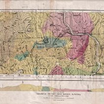
Small, coloured map depicting the geology of Southern Rossland Mountain Group, Selkirk Valley, Bonnington Range (Selkirks). There is a legend on the left-hand side depicting the geology types represented on the map. At the bottom above the title there is an altitude schematic showing the highest peaks and lowest valleys of the area. Besides the major mountains, creeks, railroads, and the cities of Rossland and Trail are marked. Map 81A "to accompany Geological Survey No. 38" sheet no. 8. |
Year Range from |
1890 |
Year Range to |
1930 |
Size |
75 x 42.5 |
No. of sheets |
1 |
Medium |
Paper |
Search Terms |
Red Mountain Railway Canadian Pacific Railway |
Subjects |
Geology Rossland Range Valley Bonnington Lake Topographic Creek Railway Monzonite Volcanic Formation |
Additional Information |
https://www.rosslandmuseum.ca/geology |