Archive Record
Images
Metadata
Catalog Number |
A2020.000.347 |
Object Name |
Map |
Tagline |
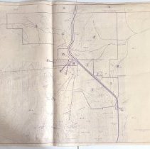
Map showing property ownership and old mineral claims around the Red Mtn. Ski Area. |
Collection |
MS 23 - Red Mountain Ski Club Collection |
Scope & Content |
A map that shows property ownership and old mineral claims around the Red Mtn. Ski Area. The map was printed with light purple ink. The map is measured with imperial units. Faint contour lines of individually drawn trees mark forested areas. The peaks of Red + Granite Mtns are prominent, with elevation noted beneath the names. The Red Mtn. chair, Granite chair, and Poma lift are all marked, along with the Red Mtn. lodge. The highway going through the area is marked with a thick line. Old mineral claims are marked with thin dotted lines; some of these claims include Good Hope, Northern Belle, Cracker Jack, Morning Star, and Blue Elephant. Property lines are denoted by much thicker dotted lines and lettered "A" - "L". There is a key to the right of the map for which letter corresponds to which owner. The properties are listed, in alphabetical order; Red Nab. Developments Ltd, Sandner Bros, Richard Mann, Red Mtn Hotel, Granite Mtn. Developments, Carl Price, Red Shutter Inn, Old Glory Inn, C.E. Cetoria, Muffly, T.Feeney, and Block Motel & Trailer Park. Buildings are marked with solid shapes reflecting their real world shape. Some old mining buildings + roads are marked, such as those in the Good Hope Claim. |
Date |
1970/10/ |
Size |
128.7 cm x 75.7 cm |
No. of sheets |
1 |
Medium |
Paper |
People |
Mann, Richard Price, Carl Letoria, C.E Feeney, T. |
Search Terms |
Red Mountain Granite Mountain Good Hope Mining Claim Northern Belle Mining Claim Cracker Jack Mining Claim Morning Star Mining Claim Blue Elephant Mining Claim Red Mountain Chairlift Granite Mountain Chairlift Poma Chairlift Red Mountain Ski Lodge |
Subjects |
Skiing Mining Topographical Map Survey |