Archive Record
Images
Metadata
Catalog Number |
A2020.000.113 |
Object Name |
Map |
Tagline |
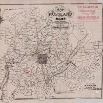
H.R. Knapp's Map of Rossland and Its Mine. |
Collection |
MS 84 - Map & Plan Collection |
Scope & Content |
Mining claim map of the Rossland area with the town of Rossland marked. There are a few hundred claims listed, including the major producing mines. Some of the claims include: Vulcan, Runover, Tip Top, Ida May, War Eagle, Centre Star, Le Roi, Black Bear, Iron Colt, Good Hope, Jumbo, and Blackberry. The Canadian Gold Fields Syndicate Ltd put out the map/this printing of it and its location marked in red with a pointing hand on the lower left quarter (Gold Hunter/Alabama/Sunset claims). Other features on the map include: Red Mountain Railway, Columbia & Western Railway, Trail Creek, and the wagon road. Published is listed on the lower right. The top right corner is marked with "The Walters Co. (Limited Liability) Mining Brokers Agents for the Canadian Gold Fields Syndicate, Ltd. Rossland, British Columbia" in red. The map was sold for 25 cents. |
Date |
1897/03/01 |
Size |
58.5 x 50.5 |
No. of sheets |
1 |
Medium |
Tissue Paper |
Search Terms |
Red Mountain Railway Columbia & Western Railway Dewdney Trail Trail Creek War Eagle Mine Centre Star Mine Le Roi Mine Black Bear Mine Jumbo Mine Iron Colt Mining Claim Good Hope Mining Claim Ida May Mining Claim Vulcan Mining Claim Blackberry Mining Claim Runover Mining Claim Canadian Gold Fields Syndicate The Walters Co |
Subjects |
Mining Map Mining Claim Town Layout Railway Trails Wagon Road Underground Mining |