Archive Record
Images
Metadata
Catalog Number |
A2020.000.213 |
Object Name |
Map |
Tagline |
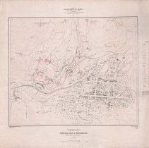
Topographical Sheet Special Map of Rossland British Columbia produced by Canada Department of Mines Geological Survey Branch - 1908. |
Collection |
MS 84 - Map & Plan Collection |
Scope & Content |
Coloured topographical map of Rossland and the surrounding area. The city of Rossland is depicted from Union Avenue through Seventh Avenue and Monita through Georgia Streets. If there are buildings on the blocks, they're shaded in. If the mine had surfaced buildings they are marked. The mining claims with buildings include the War Eagle, Centre Star, Le Roi, Josie, White Bear, Number One, Iron Mask, Gertrude, Virginia, Iron Horse, and Nickel Plate claims. The majority of the remaining claims outside of town are marked with their names. The Red Mountain and Columbia & Western railway lines and stations are marked. Other elements of note include the tennis court, roman catholic hospital, court house, drill hall, post office, fire station, quarry, and city hall. The contour lines have the elevation marked and any river/creek or coloured blue. There is a legend explaining the elements and symbols used on the map on the right side of the page. The map is based on a survey completed in 1905-1906 and done by W.H. Boyd. The map is No. 1001. |
Date |
1908/ / |
Size |
70 x 59.5 |
No. of sheets |
1 |
Medium |
Linen |
Search Terms |
Le Roi Mine Centre Star Mine Josie Mine War Eagle Mine Iron Mask Mine Nickel Plate Mine Rossland Tennis Court Rossland City Hall Rossland Drill Hall |
Subjects |
Mining Mining Claim Mine Buildings Mill City Layout Hospital Fire Station Railway City Block Topography |