Archive Record
Images
Metadata
Catalog Number |
A2020.000.345 |
Object Name |
Map |
Tagline |
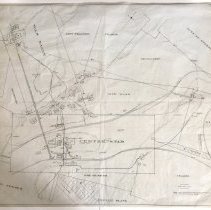
Map showing the surface facilities on the War Eagle and Centre Star mines. |
Collection |
MS 84 - Map & Plan Collection |
Scope & Content |
A map that shows the location of buildings, roads, and fire hydrants servicing the Centre Star and War Eagle mines. Most of the map is drawn in black, however hydrants and the water lines that supply them are coloured blue. There is one proposed fire hydrant noted at the Centre Star property. Part of Third Avenue and Davis Street with housing lots is shown, along with a sidewalk that runs up to the Centre Star grounds. A wagon road is marked going through Centre Star up to War Eagle and beyond. The War Eagle Gravity Tramway is shown as multiple parallel lines starting at the War Eagle Head Works and ends at the War Eagle Ore Bins next to Centre Star's boiler house. Other facilities shown include blacksmith and machine shops, bunk houses, warehouses, an assay Office, and stables. The C.P.R. is shown running left to right just under the Centre Star boiler house and War Eagle ore bins. Some areas are numbered with red pen, other land claims such as Le Roi, Iron Mask, and Josie are marked; however, their facilities are not mapped. *On the left and right edges of the map's reverse are words noting this as an insurance map. |
Size |
116.5cm x 91.7cm |
No. of sheets |
1 |
Medium |
Drafting Linen |
Search Terms |
Rossland, BC Centre Star Mine War Eagle Mine CPR Canadian Pacific Railway |
Subjects |
Mining Mining Claims Mine Site Tramway Ore Movement Railway Warehouse Assay Office Ore Bin |