Archive Record
Images
Metadata
Catalog Number |
A1996.34.1 |
Object Name |
Map |
Tagline |
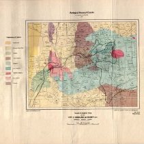
Geological map of the Rossland area produced by the Geological Survey of Canada in 1906. |
Collection |
MS 84 - Map & Plan Collection |
Scope & Content |
Coloured geological survey of Canada map no. 941. Geological map showing the town of Rossland, the surrounding mining claims, railway tracks, and major creeks and trails marked. The map is coloured to represent the geological features of the region. A legend for the geological colouring is to the left of the map. Features include the Dewdney Trail, Little Sheep Creek, Red Mountain Railway, and the Columbia & Western Railway. There are approximately 200-250 claims marked on the map. All of the major Red Mountain mining claims are listed (Le Roi, Josie, Black Bear, War Eagle, Centre Star). The map was sold for 10¢. The geological boundaries were done by G.H. Young. |
Date |
1906/ / |
Size |
46.5 x 37.1 |
No. of sheets |
1 |
Medium |
Paper |
Search Terms |
Red Mountain Railway Columbia & Western Railway Dewdney Trail Josie Mine War Eagle Mine Centre Star Mine Le Roi Mine Black Bear Mine Little Sheep Creek |
Subjects |
Mining Mining Claim Mineral Claim Geology Railway Map |