Archive Record
Images
Metadata
Catalog Number |
A2020.000.290 |
Object Name |
Map |
Tagline |
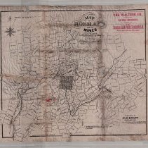
H.R. Knapp's Map of Rossland and it's Mines - 1897. |
Collection |
MS 84 - Map & Plan Collection |
Scope & Content |
Mining claim map with several hundred mining claims marked. The town of Rossland is marked and consists of 63 blocks. Both the Red Mountain and Columbia & Western railways are marked as well as the wagon road and Dewdney Trail. Some of the mining claims included on the map are: Le Roi, Josie, Black Bear, War Eagle, Centre Star, Iron Mask, Viking, Silverine, Big Trout, St. Louis, Comet, Rainy Day, Deadwood, White Swan, Spotted Trail, Gold Dollar, and Mispickel. Although produced by H.R. Knapp, the map was used as promotional material by Walters Co., mining brokers and agents of the Canadian Gold Fields Syndicate. The Sydicate's location is marked on the map (Sunset claim) by a red pointing hand. There is a copyright note on the lower right side of the page. There is also a note that states that the map was "entered according to act of parliament of Canada in the year 1897" by C.H Ellagott at the Department of Agriculture. Maps were sold for 25 cents. |
Date |
1897/ / |
Size |
60 x 49.5 |
No. of sheets |
1 |
Medium |
Tracing Paper |
Search Terms |
Red Mountain Railway Columbia & Western Railway Centre Star Mine Trail Creek Le Roi Mine War Eagle Mine Iron Mask Mine Josie Mine Black Bear Mine White Bear Mine |
Subjects |
Mining Mining Claim Mineral Claim Railway Creek Townsite Road |