Archive Record
Images
Metadata
Catalog Number |
A1998.15.3 |
Object Name |
Map |
Tagline |
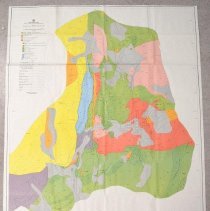
Large coloured geological map of the Rossland area produced by the BC Ministry of Energy, Mines, and Petroleum Resources. |
Collection |
MS 84 - Map & Plan Collection |
Scope & Content |
This topographic map shows geological formations in the vicinity of Rossland. The map is in full colour, with each colour representing groups of geological formations. Formations in the Rossland Group are coloured green, while those of the Mount Roberts formation are blue. These are further differentiated by a number-letter combination, such as 2a or 1c. Formations which are not a part of either group are also noted, such as Serpentine (purple-grey) and Rossland Monzonite (red). All information is shown in the Legend to the left of the map. Prospect locations are shown, along with triangulation stations at the peaks of mountains. The scale is in metric, however, topography contours are in imperial units. Mine features and fault lines are also marked. Rossland is shown as a collection of roads. Credit for geology goes to James T. Fyles. |
Year Range from |
1967 |
Year Range to |
1971 |
Size |
127cm x 97cm |
No. of sheets |
1 |
Medium |
Paper |
People |
Fyles, James T. |
Search Terms |
Rossland, BC Mount Roberts Geological Map Topographical Map BC Ministry of Energy, Mines, and Petroleum Resources |
Subjects |
Geology Geological Map Topographical Map Topography |
Additional Information |
https://www.rosslandmuseum.ca/geology |