Archive Record
Images
Metadata
Catalog Number |
A2020.000.235 |
Object Name |
Map |
Tagline |
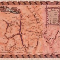
Kootenay Heritage and Minerals Map 1880-1897. |
Collection |
MS 84 - Map & Plan Collection |
Scope & Content |
Illustrative map that shows the railways, towns, mines, rivers, and traditional Indigenous camp locations. The railways depicted include: Nelson Fort Sheppard, Kootenay, Columbia Western, Kalso Slocan, Nakusp Slocan, and the proposed Crowsnest Pass Railway. Some of the towns include but are not limited to: Joseph’s Prairie (Cranbrook), Fisherville, Nashton, Rossland, Slocan City, Trout Lake City, Trail Creek Crossing (Trail), Salmon Siding (Salmo), Nelson, and Ainsworth. The lakes and rivers of the area and coloured a red/brown colour. The mountains are represented by small triangles dispersed around the map (not representative of the amount of mountains in the area). The indigenous encampments are marked by a teepee and both the indigenous and translated names. The Canada-USA border is marked at the bottom of the map. There is a legend with all of the symbols used on the map in the upper right corner of the map. The map was researched and sketched by S. Reynolds. The top of the legend states that the population of the Kootenays in 1897 was an estimated 21,000 people. |
Year Range from |
1880 |
Year Range to |
1897 |
Size |
55 x 43 |
No. of sheets |
1 |
Medium |
Paper |
Search Terms |
Dewdney Trail Le Roi Mine Columbia & Western Railway Nelson & Fort Sheppard Railway St. Eugene Mine Sullivan Mine Blue Bell Mine Kalso Slocan Railway Kootenay Railway Trail Creek Crossing North Star Mine Crowsnest Pass Railway Silver King Mine |
Subjects |
Railway Mine Trail Placer Gold Mining Town Rivers Mineral Extraction International Border Indigenous Territory Mineral Extraction Ferry Lead Zinc Copper Silver |