Archive Record
Images
Metadata
Catalog Number |
A2020.000.150 |
Object Name |
Map |
Tagline |
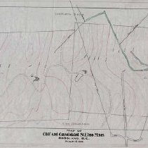
Map of Cliff and Consolidated St. Elmo Mines. |
Collection |
MS 84 - Map & Plan Collection |
Scope & Content |
Large mining claim map that has eight mining claims depicted as well as the underground workings of the Cliff and Consolidated St. Elmo Mines. The claims listed include: St. Elmo, Consolidated St. Elmo, Cliff, Southern Belle, Red Mountain, Mabel (June 1911), Eddie J., and Ida May. The tunnels on the Cliff claim are coloured differently to distinguish between them (legend on the bottom), while the rest of the underground development depicted on the map is marked. There are several diamond drill holes marked on the map. The map has pink contour lines with elevations listed (mainly come from CGS Map 1002). The map is labelled "#22" in the bottom right corner. |
Size |
98.5 x 41.4 |
No. of sheets |
1 |
Medium |
Drafting Linen |
Search Terms |
Cliff Mining Claim St. Elmo Mine Consolidated St. Elmo Mining Claim Red Mountain Mining Claim Ida May Mining Claim Eddie J. Mining Claim Mabel Mining Claim Cliff Mine Southern Belle Mining Claim |
Subjects |
Mining Mining Claim Mineral Claim Mine Tunnel Open Cut |