Archive Record
Images
Metadata
Catalog Number |
A2021.000.001.028 |
Object Name |
Map |
Tagline |
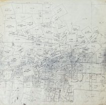
Map of the mining claims in the immediate Rossland area. |
Collection |
MS 84 - Map & Plan Collection |
Scope & Content |
Large-format copy of a mining claim map of immediate Rossland area. The map features not only the mining claims surrounding Rossland but also various land lots and the town itself. The city of Rossland is in the centre of the map and shows the streets and division of the blocks. Each of the blocks is numbered and the town is shown from Enterprise Avenue to Princess Avenue and Ottawa Street to View Street. The placement of the Columbia & Western Railway tracks is also shown throughout Rossland. All of the mining claims depicted have a name and lot number. Some mining claims include: War Eagle, Black Bear, Centre Star, Josie, Le Roi, Evening Star, Ida May, St.Elmo, Cliff, Northern Belle, Snowshoe, Silverine, Good Hope, Good Friday, Mountain View, Tip Top, North Star , Caledonia, Noonday, Duluth, Randolph, Old Sport, Freeburn, Mary D., and Mispickle. |
Size |
92 x 107 |
No. of sheets |
1 |
Medium |
Paper |
Search Terms |
Le Roi Mine Eddie J. Mining Claim Silverine Mining Claim War Eagle Mine Golden Chariot Mining Claim Josie Mine Centre Star Mine Black Bear Mine Evening Star Mining Claim Tip Top Mining Claim Copper Jack Mining Claim Jumbo Mine Snowshoe Mining Claim Northern Belle Mining Claim Cliff Mining Claim St. Elmo Mining Claim |
Subjects |
Mining Mineral Claim Mining Claim Land Lots City Streets City Planning City Layout |